La Mostra The Making of Modern-day Rome Papal Plans for Urban Redevelopment and the Town’s Road System
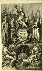
Map of Rome. Engraving by Mattheus Merian based on Antonio Tempesta's map of 1593
This delightful representation of the city of Rome as viewed from the Janiculum Hill was engraved in the mid-1600s by Mattheus Merian. It reproduces the perspective map drawn “from life” by Antonio Tempesta in 1593. The map depicts Rome at the end of the sixteenth century, including the major urban transformations undertaken under the papacies of Gregory XIII and Sixtus V, with wide, straight roads connecting the city’s main hubs, and the tall obelisks that Sixtus V had erected in St Peter’s Square, the Lateran, St Mary Major and Piazza del Popolo. The map lacks a number of monuments that later became symbols of the city but had not yet been built at that time: Bernini’s colonnade in St Peter’s Square, the Fontana dei Fiumi in Piazza Navona, the Trevi Fountain and the Spanish Steps.
Antonio Tempesta (draw.), Mattheus Merian (engr.), Roma, in: Martin Zeiller, Itinerarium Italiae nov-antiquae..., Frankfurt am Main 1640
Urban renewal under Nicholas V
The “Diario della città di Roma”, by Roman chronicler Stefano Infessura, is one of the most important sources on Rome in the latter half of the fifteenth century. This excerpt from the “Diario” not only tells of the great influx of pilgrims in 1450 and the notorious Sant'Angelo Bridge accident, it also mentions Nicholas V’s urban renewal plan in the run-up to the Jubilee and immediately afterwards. The Pope, who was to die a few years later in 1455, called in Leon Battista Alberti as a consultant on his new plan for Rome
Stefano Infessura, Diario della città di Roma di Stefano Infessura scribasenato, nuova edizione a cura di Oreste Tommasini, Roma 1890
Extension and renewal of the Vatican Library under Nicholas V
It was pope Nicholas V, a humanist and a patron of the fine arts and letters, who opened the modern history of the Vatican Library: the Pope greatly increased the wealth of Latin, Greek and Hebraic codexes (from 350 they hit about 1200) and decided that they may be consulted by scholars.This initiative fully belongs to the project of renewal of Rome greatness and prestige wanted by the Pope. His successor, Sixtus IV, completed the work, appointed a librarian and granted the Library the required economic support.
Vespasiano da Bisticci, Virorum illustrium CIII qui saeculo XV extiterunt vitae..., in: Angelo Mai, Spicilegium romanum, vol. I, Roma 1839
Sant'Angelo Bridge
On Ponte Castel Sant'Angelo happened the accident related by Infessura in consequence of which Sixtus IV got built a new bridge in view of the Jubilee of 1475.
Castel S. Angelo, in: Fioravanti Martinelli, Roma di nuovo ricercata nel suo sito... Di nuovo con ogni diligenza corretta & accresciuta con belle figure, Roma 1702
Sisto Bridge
Pope Sixtus IV commissioned Ponte Sisto in the run-up to the 1475 Jubilee, after an accident took place on Ponte Sant’Angelo during the 1450 Jubilee. Construction work began on 29 April 1473, funded in part by a luxury tax introduced that year. The new bridge made it easier for pilgrims to travel between the Vatican and the city’s commerce and tourism hub, which was around Campo de’ Fiori, Piazza Navona and Via dell’Orso.
Aegidius Sadeler, Vestigi delle antichità di Roma, Tivoli, Pozzuolo et altri luoghi, Praga 1601
Public works in Rome for the 1475 Jubilee under Sixtus V
In his description of the 1475 Jubilee, humanist Sigismondo dei Conti tells of the many works Sixtus IV commissioned to prepare the city for pilgrims. These included a remodelling of the Ospedale di S. Spirito in Sassia – a project that began in 1471 and was completed only in 1478.
Sigismondo dei Conti, Le storie de' suoi tempi dal 1475 al 1510..., vol. I, Roma 1883
The works wanted by Sixtus for the Jubilee of 1475 according to Platina
Battista Platina, Historia delle vite de i sommi pontefici dal salvator nostro sino a Clemente VIII..., Venezia 1594
The Bull "Etsi de cunctarum civitatum" of 30 June 1480
The attention fastened to city embellishment by Sixtus IV doesn't end with the Holy year. So, after pre-jubilee "urgency" works, with the bull Etsi de cunctarum civitatum on 30 June 1480, the pontiff reorganizes urban building sector and introduces in fact private property expropriation for reasons of public interest, by promoting the possibility of buying adjacent buildings and demolishing run-down or medieval-looking houses, making room for further enlargements and the building of wider and more decent properties.
Sisto IV, Etsi de cunctarum civitatum (30 giugno 1480),in: Statuta almae Urbis Romae auctoritate s.d.n. d. Gregorii papae XIII pont. max. a senatu, populoq. rom. reformata et edita, Roma 1580
Alexander VI's Bull for the opening of Via Alexandrina at Borgo
The road that Alexander VI commissioned to be built between the Borgo Vecchio and Borgo Sant’Angelo, known as Via Alexandrina or Via Recta before being renamed Borgo Nuovo, was solemnly inaugurated on 24 December 1499, as the Holy Door was being opened at St Peter’s in a ritual also inaugurated for the first time by Alexander VI.
Alessandro VI, Etsi universis (1500), in: Magnum bullarium romanum... opus absolutissimum Laertii Cherubini..., editio novissima quinque tomis distributa..., vol. I,Lyon 1692
A view of Borgo Nuovo (formerly Via Alexandrina), built by Pope Alexander VI for the Jubilee of 1500
Vista de Borgo à S. Pedro, in: Compendio de las cosas mas particulares de la Santa ciudad de Roma con la noticia de sus iglesias, estaciones, reliquias, cuerpos de santos, i dotes para donzellas pobres que ai en ella. Guia puntual para que los forasteros hallen con facilidad sus mas notables maravillas... De nuevo corregido, i aumentado de laminas, i los dias de las postas de Roma para Espana, Roma 1769
Map of Rione 14, Borgo
Rione XIV di Borgo, in: Dominique Magnan, La città di Roma ovvero succinta descrizione di questa superba città con due piante generali di essa e de' XIV rioni... riveduta ed aumentata da Stefano Piale, vol. II, Roma 1826
Map of Rione IV, Campo Marzio
Campii Martii regio IV romana qualis erat anno 1777, in: Dominique Magnan, La città di Roma ovvero breve descrizione di questa superba città con due piante generali, e quelle de' suoi quattordici rioni incisi in rame per comodo de' forestieri, vol. I, Roma 1779
The changes made by Alexander VII to Piazza del Popolo
The view by Giovani Battista Falda shows Alexander VII's "buildings" for the twin churches of Piazza del Popolo, even before their real accomplishment. The building of Santa Maria in Montesanto actually began in 1662, but it stopped when the Pontiff died in 1667, to start again in 1673 under the supervision of Bernini in collaboration with Carlo Fontana. The works for the twin church of Santa Maria dei Miracoli, on the contrary, began only in 1675, ten years after the edition of Falda's engraving which represents therefore a projection of Alexander VII's project.
Giovanni Battista Falda, Altra veduta della Piazza del Popolo entrandosi nella città, in: Id., Il nuovo teatro delle fabriche et edificii in prospettiva di Roma moderna..., vol. I, Roma 1665
View of Piazza del Popolo in the 18th century
Giovanni Battista Cipriani, Piazza del Popolo, in: Id., Vedute principali e più interessanti di Roma, Roma 1799
The changes made by Gregory XIII, Sixtus V and Alexander VII to Piazza del Popolo
The view by Giovanni Battista Falda shows Piazza del Popolo after sixteenth-seventeenth century works commissioned by Gregory XIII, Sixtus V and Alexander VII. Actually you can see the fountain by Giacomo della Porta, got placed in the middle of the square in 1573, prior to 1575 Jubilee, by pope Gregory XIII; the Egyptian obelisk from Circus Maximus, which got erected in 1589 by Sixtus V; the interior façade of Porta del Popolo, restored by Gian Lorenzo Bernini on behalf of Alexander VII, who also entrusted him with a mandate to work on the basilica of Santa Maria del Popolo, erected in XI century by Pascal II and rebuilt by pope Sixtus IV for the Jubilee of 1475.
Giovanni Battista Falda, Piazza del Popolo abbellita da n.s. papa Alessandro VII, in: Id., Il nuovo teatro delle fabriche et edificii in prospettiva di Roma moderna..., vol. I, Roma 1665
The transformation of Piazza del Popolo in the19th century
The Piazza took on its modern-day form in the 1800s. In 1793, architect Giuseppe Valadier presented a project to Pope Pius VI for two cavalry barracks to be built along the sides of the square. When the French arrived in Rome, they chose a design for a “public villa and promenade” commissioned from French architect Louis Martin Berthault. But when the Pope returned, it was Valadier who put this plan into practice: the piazza became the square we know today, Giacomo Della Porta’s fountain was removed and replaced by a new design; two almost identical fountains were built at the centre of the curved walls around the ellipsoid piazza, and wide linking ramps were built, decorated with trees and carriage roads to provide access to the Pincio terrace.
Giovanni Battista Cipriani, Progetto del sig. Giuseppe Valadier architetto presentato a papa Pio VI nel 1794 per decorare la Piazza del Popolo con due caserme per cavalleria ed infanteri, in: Id., Vedute principali e più interessanti di Roma, Roma 1799
The transformation of Piazza del Popolo in the19th century
The Piazza took on its modern-day form in the 1800s. In 1793, architect Giuseppe Valadier presented a project to Pope Pius VI for two cavalry barracks to be built along the sides of the square. When the French arrived in Rome, they chose a design for a “public villa and promenade” commissioned from French architect Louis Martin Berthault. But when the Pope returned, it was Valadier who put this plan into practice: the piazza became the square we know today, Giacomo Della Porta’s fountain was removed and replaced by a new design; two almost identical fountains were built at the centre of the curved walls around the ellipsoid piazza, and wide linking ramps were built, decorated with trees and carriage roads to provide access to the Pincio terrace.
Giovanni Battista Cipriani, Pianta della Piazza del Popolo e delle caserme secondo il progetto del sig. Giuseppe Valadier, in: Id., Vedute principali e più interessanti di Roma, Roma 1799
The transformation of Piazza del Popolo in the19th century
The Piazza took on its modern-day form in the 1800s. In 1793, architect Giuseppe Valadier presented a project to Pope Pius VI for two cavalry barracks to be built along the sides of the square. When the French arrived in Rome, they chose a design for a “public villa and promenade” commissioned from French architect Louis Martin Berthault. But when the Pope returned, it was Valadier who put this plan into practice: the piazza became the square we know today, Giacomo Della Porta’s fountain was removed and replaced by a new design; two almost identical fountains were built at the centre of the curved walls around the ellipsoid piazza, and wide linking ramps were built, decorated with trees and carriage roads to provide access to the Pincio terrace.
Giuseppe Valadier (inv.), Luigi Maria Valadier (draw.), Giovanni Battista Cipriani (inc.), Pianta topografica della Piazza del Popolo in Roma con nuova publica passeggiata sul Monte Pincio, in: Giuseppe Antonio Guattani, Memorie enciclopediche sulle antichità e belle arti di Roma per il 1816, Roma 1817
Gregory XIII's Bull of 1 October 1574, also known as Constitution "De aedificiis"
A fundamental urbanistic instrument, which remained in effect until about the beginning of XIX century, the constitution "De aedificiis" regulated the urban building activity prior to Holy year of 1575. By establishing the superiority of public interest on private one, it regulated the expropriation faculty of private buildings involved in the opening of new streets and obliged owners to keep the decency of the same buildings, by subjecting them to a strict public control.
Gregorio XIII, Quae publice utilia et decora(1 ottobre 1574), in: Magnum bullarum romanum... opus absolutissimum Laertii Cherubini, editio novissima quinque tomis distributa..., vol. II (A Pio quarto usque ad Innocentium IX), Lyon 1692

Via Gregoriana, known today as Via Merulana
An inscription conserved at St Mary Major states that Gregory XIII commissioned a road to be built for the 1575 Jubilee to link the basilicas of St Mary Major and St John. Originally known as Via Gregoriana, that road exists today as Via Merulana.
Nicola Ratti, Su la Basilica Liberiana, dissertazione letta all’Accademia Romana di archeologia li 9 marzo 1825..., Roma 1825
Via Gregoriana, known today as Via Merulana
An inscription conserved at St Mary Major states that Gregory XIII commissioned a road to be built for the 1575 Jubilee to link the basilicas of St Mary Major and St John. Originally known as Via Gregoriana, that road exists today as Via Merulana.
Angelo Uggeri, Via Merulana, in: Id., Journées pittoresques des édifices de Rome ancienne, suppl. voll. XXIII-XXV (Vues. Édifices de la Renaissance), Roma 1827
Via Gregoriana, known today as Via Merulana
An inscription conserved at St Mary Major states that Gregory XIII commissioned a road to be built for the 1575 Jubilee to link the basilicas of St Mary Major and St John. Originally known as Via Gregoriana, that road exists today as Via Merulana.
Nicola Ratti, Su la Basilica Liberiana, dissertazione letta all’Accademia Romana di archeologia li 9 marzo 1825..., Roma 1825
Via Gregoriana, known today as Via Merulana
An inscription conserved at St Mary Major states that Gregory XIII commissioned a road to be built for the 1575 Jubilee to link the basilicas of St Mary Major and St John. Originally known as Via Gregoriana, that road exists today as Via Merulana.
Nicola Ratti, Su la Basilica Liberiana, dissertazione letta all’Accademia Romana di archeologia li 9 marzo 1825..., Roma 1825
Portrait of Sixtus V surrounded by his urban redevelopment achievements in the city of Rome
The original reproduced by Frutaz is included in the volume by Giovanni Pinadello, Invicti quinarii numeri series. Quae summatim a superioribus pontificibus et maxime a Sixto quinto res praeclare quadrienno gesta adnumerat ad eundem Sixtum quintum pont. opt. max., printed in Rome in 1589.
1589 - Sisto V e vedutine delle opere edilizie da lui ideate e costruite, incisione edita da Giovanni Pinadelli, in: Le piante di Roma, a cura di Amato Pietro Frutaz, vol. II (Tavole dal secolo III d.C. all'anno 1625), Roma 1962
Redevelopments and works by Sixtus V in the City of Rome
Gregorio Leti, Vita di Sisto V pontefice romano..., vol. III, Amsterdam 1698
Santa Maria Maggiore, the hub of Sixtus V's road redevelopment plan
Gregorio Leti, Vita di Sisto V pontefice romano..., vol. III, Amsterdam 1698
Santa Maria Maggiore, the hub of Sixtus V's road redevelopment plan
Gregorio Leti, Vita di Sisto V pontefice romano..., vol. III, Amsterdam 1698
Santa Maria Maggiore, the hub of Sixtus V's road redevelopment plan
A map of the Monti district clearly shows the road network constructed during the last twenty-five years of the sixteenth century around St Mary Major by Gregory XIII (the Via Merulana), and above all by Sixtus V (the long, straight Via Felice and Via Panisperna).
Rione I de' Monti, in: Dominique Magnan, La città di Roma ovvero succinta descrizione di questa superba città con due piante generali di essa e de' XIV rioni... riveduta ed aumentata da Stefano Piale, vol. I, Roma 1826
Santa Maria Maggiore, the hub of Sixtus V's road redevelopment plan
The first haul of strada Felice from Trinità dei Monti toward Piazza Barberini, nowadays via Sistina.
Angelo Uggeri, Voie Sixtine,in: Id., Journées pittoresques des édifices de Rome ancienne,vol XXIX (Vues du tours des murs de Rome),Roma 1800
The new station and square at Termini
Nello Ciampi, La nuova stazione ed il piazzale di Termini, in: Roma nell'anno santo MCML (Dalla rassegna "Capitolium"), Roma 1950
Rome. The works for the new Termini station
La Settimana Incom 00360, 2/11/1949